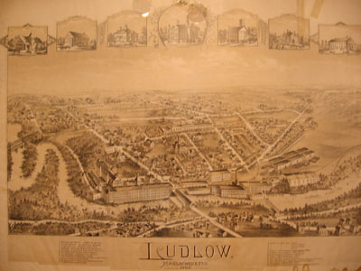
Overview of Southern Ludlow in 1895
By: Jessica B., Breanna L., and Tatiana H.
What did Ludlow Manufacturing Company look like in 1895?
What do you think life was like living in Ludlow in 1895?
How do you think people made a living in Ludlow in 1895?
Our group
looked at a map of Ludlow in 1895, titled “Ludlow, Massachusetts.” The
map was created by H. Bailey & Co. for a large audience. It shows only
the south end of Ludlow around the mills and the Chicopee River. We assume
that this was made for mill owners and mill workers.
The map includes two sets of railroad tracks and a station, which are missing now. Railroad tracks used to run through the mills by the river and another set of tracks ran through today’s Windsor Street and Hubbard Street. The tracks told us that many goods were once transported in and out of Ludlow. We also see many mills. The mills to the left and the right of the bridge no longer exist. This tells us that in 1895 the Ludlow Manufacturing Company was at its high point, but as time went on the business declined, causing the destruction of the mills. Mill number eight, also known as the clock tower, is also missing. That’s because it hasn’t been built yet.
In
addition, it shows a covered version of Put’s Bridge. Travel at this
time was by riding horses, and horses and carriages can be seen on the map. We
also notice that Center Street was once called North Street. Important
buildings and landmarks are numbered, such as the Post Office, the Union School,
and the Hubbard Memorial Library.
This map is an example of how New England was becoming industrialized. Waterways brought manufacturing to communities, and Ludlow is an example. We think this map was created at the high point of the Ludlow Manufacturing Company. We think this because there are many mill buildings on this map that are no longer standing.
