Map of 1870
By: Kayla K., Joel M., and Abby D.
What did Ludlow look like in 1870?
What are the differences and similarities between now and 1870?
What were the important places in 1870?
What were some of the roads back then that are still roads today?
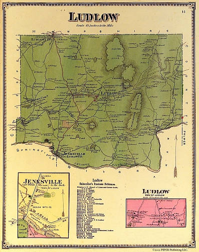
Ludlow Map, 1870
Our group
looked at a map of Ludlow printed in 1870. The map shows rivers, mountains,
streets and other important places. At the bottom of the map there are
two insets. One is of Jenksville, the area around the Ludlow Mills named
after Benjamin Jenks. In this inset we see the Ludlow Manufacturing Company. The
other inset is of the Ludlow Center. In the center of Ludlow, we see the
Town House, or Ludlow’s Meeting House.
Also, at the bottom of the map it gives the names of some of Ludlow’s first occupants and their job titles. In the list, there are 33 names, and 26 are farmers. Other jobs included postmaster, manufacturers, carpenters, and merchants. The biggest mountain in Ludlow is named Mineachoag Mountain. The important places it shows are the Town House, farms, first settlers’ homes, and Chapin Pond, which is now the Haviland Pond. This map was made before the reservoir was built in Ludlow. The map also shows the cemeteries in Ludlow and where important people lived. Some of the roads were named after settlers of the time and the roads are still roads today, such as Fuller, Miller, Kendall and Hubbard.
This map tells us that in 1870 Ludlow was still an agricultural town that was becoming industrialized near the Chicopee River. There still are farms to this present day, but fewer than in the past. Because there aren’t some of the neighborhoods we know today, we can infer Ludlow kept growing and will still grow larger.